How to start with SBAS mode?


Brief Introduction
A Satellite Based Augmentation System (SBAS) is a wide area differential Global Navigation Satellite System signal augmentation system that uses a number of geostationary satellites, able to cover vast areas, to broadcast primary GNSS data which has been provided with ranging, integrity, and correction information by a network of SBAS ground stations. While the primary purpose of SBAS is to provide integrity assurance, the use of the system also increases the accuracy and reduces position errors to less than 1 meter.
Compared with general GNSS positioning, SBAS is capable of covering vast areas, increasing accuracy, and reducing position errors to less than 1m. At present, the world's leading powers have also developed their own satellite navigation systems, such as the WAAS system of the United States, the EGNOSS of the European Union, the MSAS of Japan, the GAGAN of India, the SDCM of Russia, and the BDSBAS of China under development.
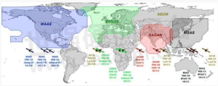
SBAS Global Distribution Map
Working Principle
The satellite-based augmentation system is composed of four parts: space constellation, ground control station, operation and maintenance station, and user. Users can broadcast a variety of correction information such as ephemeric error, satellite clock error, ionospheric delay, etc., through the geostationary orbit (GEO) satellite carrying satellite navigation augmented signal repeater to improve the positioning accuracy of the original satellite navigation system.
The navigation satellite is monitored by widely distributed differential stations (with known positions), and the original positioning data (pseudo-range, carrier phase observation values, etc.) are obtained and sent to the central processing facility (main control station). Then GNSS data from satellites are compared against the precisely documented locations of each land-based monitor. Any discrepancy is determined to be an error. Error corrections are sent to geostationary satellites and broadcast throughout the region.
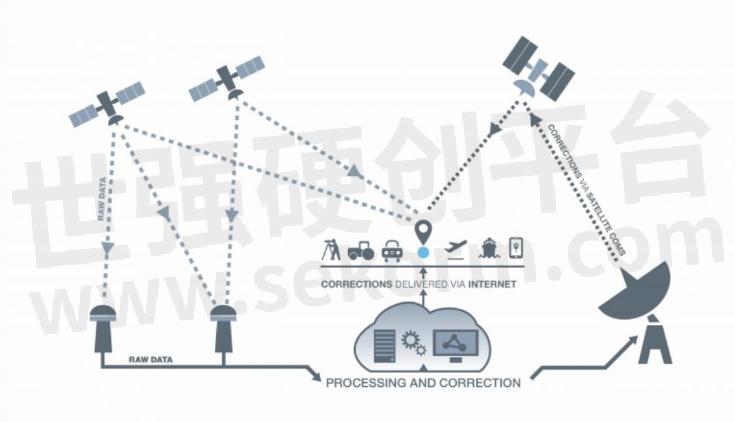
SBAS Schematic Diagram
GNSS accuracy can reach around five meters while using SBAS, users can achieve an accuracy of two meters or better. Some receivers or OEM boards can apply SBAS corrections with additional techniques to achieve sub-meter or better accuracy. Here's a step-by-step guide for you to start with SBAS mode.
We’ll take the ComNav K803 OEM module as an example. The control software is CRU, one of ComNav’s self-developed software for OEM board testing, setup, data recording, data download, and information display, you can download it for free from the ComNav website.
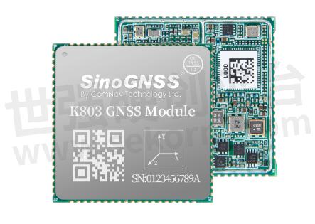
ComNav GNSS OEM Board
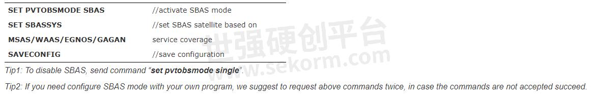
Enable SBAS Mode
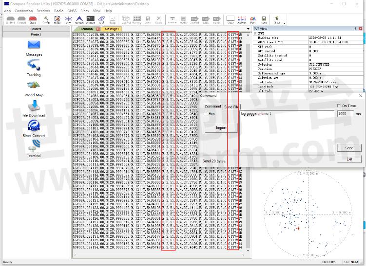
The default setting for SBAS is disabled. Users can send the following commands to activate SBAS mode in CRU software:
Status checking with GPGGA message
After sending the above commands, normally it will take 2-5 minutes to search SBAS satellites, then the board will go into the SBAS solution. You can request a GPGGA message with the command “log gpgga on time 1” to check the solution status. In SBAS mode, the solution status should be “2” and the base ID should be the SBAS satellite's PRN.
An example of GPGGA message: $GPGGA,015101.00,3121.0000551,N,12117.5483125,E,2,23,1.1,37.2598,M,0.000,M,02,0137*5
Troubleshot
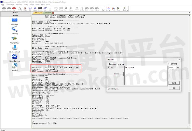
If it takes a longer time and cannot access SBAS mode, you need to check first if the configuration is successful.
Enter “LOG SYSCONFIG” to check whether SBAS mode is enabled. Enable means SBAS enabled, and Disable means SBAS not enabled.
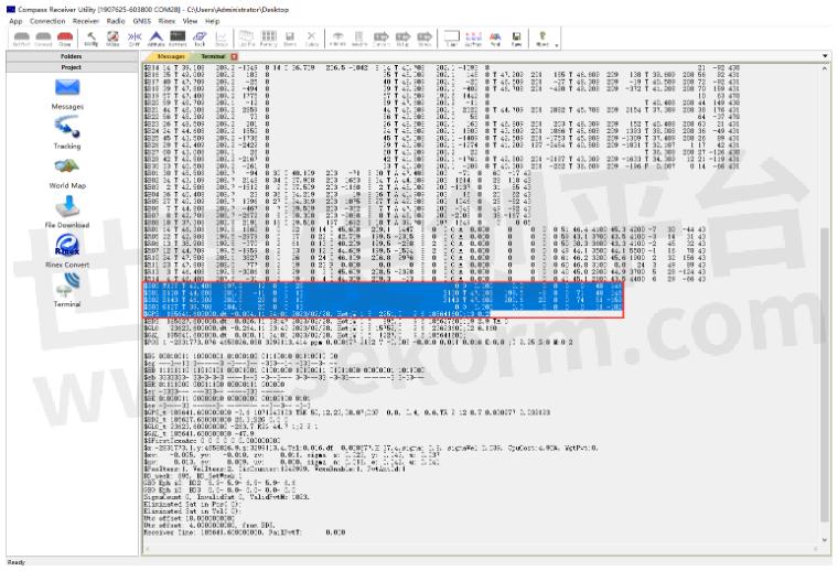
If the SBAS mode is enabled, and still cannot go into SBAS mode, you can use the command ” Log Testinfor” to check if the SBAS satellite is searchable. The satellites marked with S are SBAS satellites.
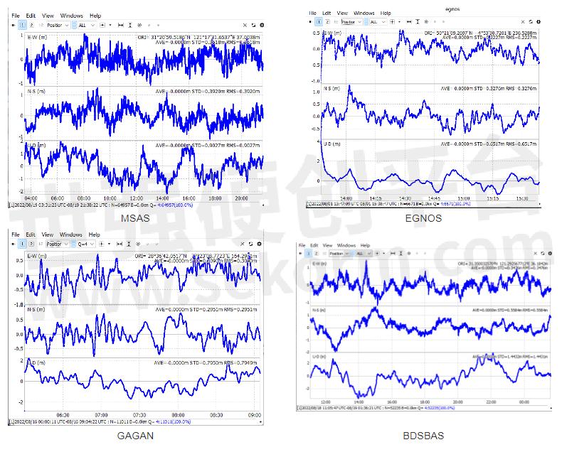
Accuracy analysis
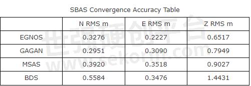
With a brand-new SBAS engine, currently we verified in Japan-MSAS, China-BDSBAS, India-GAGAN, and Europe-EGNOS. The SBAS accuracy can be very stable at 0.6 horizonal.
So far, the SBAS system is widely used in industries across aerospace, geodesy, marine navigation, personnel positioning, settlement monitoring, and other fields. Consequently, it performs well even in challenging situations, such as complex terrain, valleys, or areas with strict requirements for navigation. The most prominent benefit of SBAS is cost saving as it enables to location without receiving network differential.
About ComNav Technology
ComNav Technology is the major provider of GNSS OEM boards, receivers, and high-precision positioning solutions, encompassing product development, and marketing. Its technology and products have already been applied in a wide range of fields such as surveying, construction, machine control, agriculture, intelligent transportation, precise timing, deformation monitoring, and unmanned system. With its experienced team and innovational spirit, ComNav Technology is always trying its best to provide reliable and competitive products to global customers. In 2015, ComNav Technology was listed on the China National Equities Exchange and Quotations (NEEQ), Securities: ComNav Technology (Compass Navigation), Stock code: 833972.
About SinoGNSS®
SinoGNSS® is the official trademark of ComNav Technology Ltd., registered in the People’s Republic of China, EU, USA, and Canada. All other trademarks are the property of their respective owners.
- |
- +1 赞 0
- 收藏
- 评论 0
本文由翊翊所思转载自ComNav Technology News,原文标题为:How to start with SBAS mode?,本站所有转载文章系出于传递更多信息之目的,且明确注明来源,不希望被转载的媒体或个人可与我们联系,我们将立即进行删除处理。
相关推荐

【经验】北斗三号精密单点定位(PPP-B2b)技术及应用——以司南导航EVK-K8评估套件为例
PPP-B2b是北斗系统首次对外发布的高精度信号,由北斗三颗地球同步轨道(GEO)卫星播发,为用户提供公开、免费的高精度服务。本文将介绍北斗三号精密单点定位(PPP-B2b)技术及应用——以司南导航EVK-K8评估套件为例。
设计经验 发布时间 : 2022-07-13

Challenges of GNSS Positioning Along the Equator and Mitigation Strategies for Users
Positioning with GNSS along the equator presents unique challenges, predominantly due to ionospheric effects, satellite geometry, and multipath interference. However, with strategic approaches like employing differential corrections, using multi-constellation receivers, optimizing antenna placement, and leveraging ionospheric monitoring, GNSS users can effectively mitigate these challenges. Overcoming these hurdles will significantly enhance the reliability and accuracy of positioning solutions in equatorial regions, facilitating numerous applications across various sectors.
设计经验 发布时间 : 2024-01-13

【经验】使用手机控制司南导航K823 GNSS定位模块进行RTK差分定位实验流程
本文是一篇帮助用户使用司南导航K823模块进行RTK 定位实验的快捷操作指南,实验中使用手机app作为上位机软件发送指令控制模块,将司南导航定位模块设置为移动站,运营商基站作为基准站进行的RTK差分定位实验。
设计经验 发布时间 : 2022-09-29

司南导航定位模块/转接板选型表
GNSS高精度定位模块是司南导航自主研发的多系统多频点的小尺寸高精度定位模块,支持BDS-3、GPS、BDS-2、GLONASS、Galileo、QZSS 等卫星导航系统的信号跟踪,定位精度高,适用于物联网、智能驾驶、无人机、智能机器人等领域。
|
产品型号
|
品类
|
包装形式
|
尺寸(mm)
|
特点
|
频点
|
BDS(信号跟踪)
|
GPS(信号跟踪)
|
GLO(信号跟踪)
|
GAL(信号跟踪)
|
QZSS(信号跟踪)
|
SPP(定位精度)
|
DGPS(定位精度)
|
RTK(定位精度)
|
伪距精度(cm)
|
载波相位精度(mm)
|
速度精度(m/s)
|
I/O
|
冷启动(S)
|
热启动(S)
|
重捕(S)
|
初始化(S)
|
IO引脚
|
重量(g)
|
输入电压(V)
|
功耗(w)
|
|
K801
|
GNSS高精度定位模块
|
真空密封的铝箔放静电袋
|
12mm×16mm×2.4mm
|
小尺寸定位
|
多频
|
B1I,B2a
|
L1C/A,L5
|
G1
|
E1,E5a
|
L1C/A,L5
|
H:≤1.5m V:≤3.0m
|
H:≤0.3m V:≤0.5m
|
H:≤8+Dx10-6mm V:≤15+Dx10-6mm
|
≤10cm
|
≤1mm
|
≤0.02m/s
|
LVCMOS×2,PPS×1,EVENT×1,SPI×1
|
<24S
|
<1S
|
<1S
|
<5S
|
LGA 24Pin,1.1mm
|
3g
|
+3.3V DC
|
0.1w
|
选型表 - 司南导航 立即选型

司南导航(Comnav Technology)K8系列北斗/GNSS高精度定位模块选型指南
描述- 上海钦天导航技术有限公司是上海司南卫星导航技术股份有限公司全资子公司,成立于2022年,是一家集硏发、生产、销售、服务为一体的高精度北斗/GNSS技术领军企业,拥有一支多年专业从事高精度GNSS核心技术的本土硏发团队,主要技术骨干百余人次获得省部级及以上科学技术奖项,核心团队打破国外多项技术壁垒,突破高精度GNSS核心算法、芯片、板卡、终端、应用及产业化等关键技术瓶颈,经业内专家鉴定钦天高精度GNSS技术已达到世界先进水平,相关产品入选国家卫星导航专顼北斗基础产品推荐名录。
型号- EVK-QD302,CRU,K8-U70,RD02,K803+U70,CDL7,K系列,QD302,K803_EK0405,EVK-K823,U703,EVK-K803,K803_EK0407,K801,K823,W803,GBAS,K802,U70,K827,K803,K823_EK0407,K807,K8系列,K823+U70,K803_EK0610


【应用】司南导航高精度GNSS定位模组K803支持GPS和北斗等多模定位系统,助力割草机路径规划应用
割草机在园艺应用大大节省了人工作业成本,传统的割草机仍然需要人工操作,于是一种新型的智能化割草机已被研发出来,能够在规划的区域实现自动割草和充电。本文主要介绍司南导航K803高精度的定位和授时模块,给自动割草机提供时空信息,完成割草路径的精准规划。
应用方案 发布时间 : 2023-07-05

司南导航Q2季度全球展会行程,高精度定位领域前沿科技成果接力登场!
司南导航4~6月全球展会蓄势待发跨越9国,11场盛会高精度定位领域前沿科技成果接力登场,精彩纷呈!
厂牌及品类 发布时间 : 2024-04-29

【IC】司南导航新品单北斗全国产高精度RTK定位模组K803G/23G,低功耗高集成,引领定位技术新进程
随着北斗导航系统的建设完成,“中国芯”的研发实力日益攀升。司南导航立足产品研发,以自主创新突破技术瓶颈,K803G/K823G单北斗RTK高精度定位模组在性能、稳定性、可靠性等多方面均有突破,公司将持续攻坚,严格把好质量关,充分满足各行业高精度位置服务需求,推动北斗规模化应用高质量发展。
产品 发布时间 : 2023-11-15


司南导航(Comnav Technology)GNSS模块选型表
描述- 上海司南卫星导航技术股份有限公司成立于2012年(股票代码:688592),是国内自主掌握高精度北斗/GNSS模块核心技术并成功实现规模化市场应用的高新技术企业,集研发、生产、销售、服务为一体,致力于为全球用户提供全方位、多领域的高精度北斗/GNSS芯片、板卡、终端和系统解决方案。
型号- K827,K823E,K8,K803‐U70,K9,K803_EK0405,K803 LITE‐QD302,EVK‐K823,EVK‐K803,K802S,K823‐U70,K803_EK0407,K11,K10,K801,K823,K802,K803LITE,K803,K825,K823_EK0407,K803S5,K807,K825S,K827S,K803_EK0610,K801S,K823S

全国产单北斗系统全频点RTK定位模块K803G、K823G,具有低延迟和抗干扰等特点
K803G和K823G GNSS Module 是上海钦天导航技术有限公司基于具有完全自主知识产权的Quantum lll开发的全国产单北斗系统全频点RTK定位模块,支持BDS-2、BDS-3卫星系统信号跟踪,适用于测量测绘、机器人、地基增强等领域。
产品 发布时间 : 2023-11-07

电子商城


品牌:SILICON LABS
品类:high-performance low-current receiver
价格:¥9.5695
现货: 490
品牌:SILICON LABS
品类:HIGH-PERFORMANCE LOW-CURRENT RECEIVER
价格:¥11.9853
现货: 470


服务
拥有中等规模的SMT、DIP以及成品组装产线;支持PCBA及成品OEM/ODM代工组装制造;在嵌入式系统、物联网系统等具备专业性量产制造的项目组织和服务能力。
提交需求>
模切产品精度±0.1mm,五金模精度±0.03mm,刀模精度±0.1mm;产品尺寸:10*10mm~45*750mm,厚度范围:0.1~0.7mm。支持麦拉、导热片、导热硅胶片、导热矽胶布、绝缘导热布、小五金等材料模切。
最小起订量: 1 提交需求>
授权代理品牌:集成电路


授权代理品牌:分立元件


授权代理品牌:接插件及结构件


授权代理品牌:部件、组件及配件


授权代理品牌:电源及模块


授权代理品牌:电子材料


授权代理品牌:仪器仪表及测试配组件


授权代理品牌:电工工具及材料


授权代理品牌:机械电子元件


授权代理品牌:加工与定制


登录 | 立即注册
提交评论