XSENS Motion Tracker Helps Innok Robotics Pioneers Sensor Fusion Agv Location In Complex Outdoor Terrains

It is generally easier to design automated ground vehicles (AGVs) for indoor than for outdoor use. Inside a warehouse, for instance, an AGV moves on a smoothly finished, flat surface, in an area enclosed by walls, and along fixed, dedicated routes which are marked with barriers or guidelines for navigation, and which eliminate the risk of collision with people or other objects.
Few companies have successfully mastered the much more difficult challenge of making a robotic vehicle which can be deployed outside, on mixed terrain. Among the pioneers in this field is Innok Robotics, based in Regenstauf (near Regensburg), Germany. And the solution which it uses for tracking the position of its AGVs with centimeter-level precision is a form of dead reckoning using the inputs from a sophisticated MTi-30 AHRS motion tracker from XSENS.
A teachable robot
Innok Robotics supplies completely finished robots such as the INDUROS transport robot or the RAINOS pouring and watering robot, and also modular development platforms that researchers and manufacturers can use as the basis for application-specific AGVs. Innok Robotics is also developing a new range of standard AGVs for new applications, such as robotic ground transport between warehouses on a campus or in an industrial park.
Innok Robotics’ designs have to solve both mechanical and computing problems. The mechanical problems arise from the operating conditions. A development platform for agricultural AGVs, for instance, must be able to climb and descend slopes, move as comfortably on soil or rock as on asphalt, and operate in all weathers and temperatures.
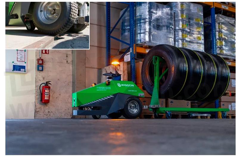
Fig.1
The Innok Robotics AGVs'traction system can handle all types of terrain - even extreme ground sills are no problem
Innok therefore pays close attention to the materials used in the manufacture of its AGVs, the environmental sealing, and the traction system.
The main computing problem which Innok Robotics solves is SLAM – Simultaneous Mapping and Localization. While a warehouse AGV operates in a stable, confined, flat environment, outdoors there are no boundaries, the terrain must be mapped and traversed in 3D, and the scene constantly changes as plants grow or are pruned, cars are parked or driven away, and so on.
Innok Robotics has developed a solution to this problem which can be applied in a wide variety of user-defined spaces. Its solution depends in part on an ability to continuously track in precise detail the movement of the AGV from a known starting point in all three dimensions. For this function, Innok Robotics has selected for its modular development platforms an Xsens MTi-30 AHRS (Attitude and Heading Reference System), a type of motion tracker which measures acceleration in 3D, and heading by reference to magnetic North. The AHRS fuses the raw acceleration data with data from its gyroscopes and magnetometers to produce estimates of roll, pitch and yaw which are updated at a rate of up to 400Hz.
A typical example of the way that Innok Robotics'SLAM technology is implemented is a specialist AGV, Rainos – a fully automated system for watering the floral displays and flower beds planted at graves in graveyards.
This is a highly specialized application for robotics, but it has a high value for professional gardeners, who are typically employed by families to water the graves of their loved ones. Performed manually, this irrigation task is tedious, laborious and time-consuming, but is not paid well. This makes it an ideal application for robotics.
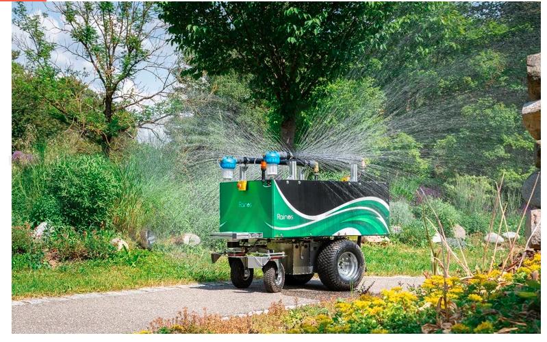
Fig.2 The Rainos AGV – an automatic system for watering graves
Innok's Rainos AGV performs the task entirely autonomously – but it can only do so because it is a teachable robot: in the initialization phase, the gardener ‘shows’ Rainos how to perform the task. Using a remote control, the gardener guides the AGV along all permitted routes, and tags the locations of graves to be watered, and of water refill points. Crucially, the gardener will also record the AGV’s parking station – the known start point from which each irrigation session begins.
During initialization, the Rainos AGV will create its own map of the graveyard, using inputs from three sources:
• A LiDAR sensor which builds a 3D map of the scene
• Odometry – motion data derived from the turning of the wheels
• A motion tracker, which provides 3D motion data and heading information
After initialization is finished, the Rainos AGV has a complete 3D map of the graveyard, the routes by which it is able to travel round the graveyard, and the locations in which it must perform watering operations.
This is how Innok Robotics' products solve the SLAM problem in real time: an Innok Robotics AGV can determine its position by a process of dead reckoning from a known starting position, using accurate, low-drift motion and heading data from an MTi-30 AHRS. And a combination of the stored map and real-time ranging inputs from a LiDAR sensor make it aware of its environment, even as the surroundings change due to factors such as the growth or pruning of vegetation, or the appearance or removal of obstacles. A powerful on-board computer enables the AGV to re-calculate its route continually to avoid obstacles while still completing its mission.

Fig.3
An Innok Robotics AGV showing the Xsens MTi-30 motion tracker on the center cross-bar
Innok Robotics's Director of Sales Alexander Hoegerl says that the company’s technological achievement depends on sensor fusion – combining multiple data inputs to create a more detailed and accurate picture of the environment around the AGV than any one sensor could provide on its own.
He says, ‘the data from the motion tracker is a crucial element of our AGVs’ position calculations, so the accuracy and low drift of the MTi-30 are really important attributes. It’s a robust device as well, its IP65 rating means that it is suitable for use outdoors, and that gives us the freedom to locate the sensor wherever the design requires.
‘What makes the MTi-30 particularly attractive for us is that it is also easy to implement in new designs. In our business, which involves constantly creating new prototypes and systems for specific applications, we have to manage development time carefully, and so it’s really helpful to us that the Xsens AHRS is easy to integrate into our system designs.’
The MTi-30 is discontinued now. As a replacement we offer two AHRS options: MTi-630 and the MTi-630R (rugged).
- |
- +1 赞 0
- 收藏
- 评论 0
本文由三年不鸣转载自XSENS News,原文标题为:INNOK ROBOTICS PIONEERS SENSOR FUSION AGV LOCATION IN COMPLEX OUTDOOR TERRAINS,本站所有转载文章系出于传递更多信息之目的,且明确注明来源,不希望被转载的媒体或个人可与我们联系,我们将立即进行删除处理。
相关推荐

XSENS的IMU惯性测量单元具有完整传感器融合算法、精度高,一流硬件设计,支持多种集成等级 |视频
3D运动追踪技术和产品的主要创新者XSENS的IMU惯性测量单元:完整传感器融合算法;精度高;一流硬件设计,支持多种集成等级。在AGV、自动驾驶、卫星天线、安防、航天航空等多个领域中广泛应用。
原厂动态 发布时间 : 2023-03-21

Melexis Sheds Light on Robotics and Mobility Technology at electronica 2024
Tessenderlo, Belgium, 5 September 2024 – Melexis, a global supplier of micro-electronic semiconductor solutions, is set to showcase its latest innovations at electronica 2024 (B4.540), the premier event for electronic components, systems, applications, and solutions.
原厂动态 发布时间 : 2024-09-10

Xsens携动捕产品亮相世界人工智能大会(WAIC)
Movella旗下的Xsens在人形机器人开发、自动驾驶、各种无人设备中得到广泛应用,本次活动与合作伙伴携手出席并展出Xsens动捕产品。
原厂动态 发布时间 : 2024-06-25

Xsens IMU惯性测量传感器选型指南
目录- IMU
型号- MTI-1,MTI-2,MTI-600,MTI-300,MTI-7,MTI-100,MTI-200,MTI-G-710,MTI-3,MTI-680,MTI-670,MTI-610,MTI-620,MTI-630

XSENS MTi系列MEMS惯性传感器选型指南
描述- Xsens是3D运动追踪技术和产品的主要创新者,其传感器融合技术可应用于消费电子设备和专业应用,诸如运动捕捉、运动分析、医疗保健、体育和工业等应用中,实现现实世界和数字世界之间的无缝交互。
型号- MTI 100-系列,MTI 1-系列,MTI-G-710,MTI 1系列,MTI 600系列,MTI 600,MTI-670,MTI 1,MTI-610,MTI-630,MTI 100,MTI-1,MTI-680G,MTI,MTI-2,MTI-670G,MTI-7,MTI系列,MTI-3,MTI 600-系列,MTI-680,MTI-200,MTI-100,MTI 100系列,MTI-620,MTI-300

Xsens MTi-30 AHRS惯性传感器提供精确数据进行精准定位,以厘米级的精度追踪AGV的位置
生产出一款可以在室外混合地形上部署的AGV,很少有公司能完成这一艰巨的挑战。来自德国的Innok Robotics公司是这一领域的先驱之一。Innok Robotics使用Xsens MTi-30 AHRS惯性传感器提供的精确数据来进行精准定位,以厘米级的精度追踪AGV的位置。
应用方案 发布时间 : 2024-01-18

Advanced HamiltonJet Propulsion Control System Uses MTi Motion Tracker to Keep A Boat Still on Moving Water
HamiltonJet‘s JETanchor product for station keeping, or providing a ‘virtual anchor‘, is an optional feature of the AVX propulsion control system. Playing a vital role in the JETanchor‘s position sensing system is an MTi-2 Vertical Reference Unit (VRU) from Xsens. The accuracy and stability of the MTi-2 VRU enable the JETanchor product to achieve high performance. It can typically maintain a vessel‘s position to within 1m at sea. System tests have demonstrated the system‘s ability to maintain a cargo vessel‘s station 1m from a wharf while a 1 tonne load of bricks was lifted by crane to shore.
应用方案 发布时间 : 2020-12-18


【应用】Xsens惯性传感器MTi-600系列为建筑业提供挖掘解决方案,支持实时计算基坑体积及数据输出
SDX-4DVision是一款结合高科技激光扫描仪和摄像机的系统,可以计算出挖掘基坑的三维尺寸。实时运动数据由Movella惯性传感器提供,Xsens MTi-630R AHRS,提供加速度、转弯率和航向角信息,这样就可以持续跟踪臂架相对于挖掘机底盘的位置。
应用方案 发布时间 : 2023-03-18

MTi 600-series IMU | VRU | AHRS | (RTK-) GNSS/INS
型号- MTI 600-SERIES,MTI-680G,MTI 600,MTI-670,MTI-610,MTI-620,MTI-630

General information for Xsens MTi series MTi Family Reference Manual
型号- MTI 600-SERIES,MTI SERIES,MTI-G-710,MTI-670,MTI-610,MTI-630,MTI 10-SERIES,MTI-30,MTI-10,MTI-680G,MTI-1,MTI,MTI-2,MTI-7,MTI 1-SERIES,MTI 100-SERIES,MTI-3,MTX,MTW,MTI-200,MTI-100,MTI-G,MTI-620,MTI-300,MTI-20
MTi 600-series Data Sheet IMU, VRU, AHRS and GNSS/INS module
型号- MTI 600-SERIES,MTI-6X0,MTI-670-DK,MTI-630-DK,MTI-670,MTI-600,MTI-610,MTI-620,MTI-630,MTI 6X0-SERIES

现货市场

授权代理品牌:集成电路


授权代理品牌:分立元件


授权代理品牌:接插件及结构件


授权代理品牌:部件、组件及配件


授权代理品牌:电源及模块


授权代理品牌:电子材料


授权代理品牌:仪器仪表及测试配组件


授权代理品牌:电工工具及材料


授权代理品牌:机械电子元件


授权代理品牌:加工与定制


登录 | 立即注册
提交评论