ComNav Technology Launched GNSS High Precision Positioning Solution for Lawn Mower


In recent years, we have seen an increase in the popularity of environmentally friendly and intelligent robotic lawn mowers. Mowing is becoming more convenient, safe and easy-to-do.
The navigation and positioning of mowers are crucial for their autonomous operation. For the automatic and intelligent operation of lawn mowers, ComNav Technology provides high-precision positioning solutions.

I. R&D background
It is difficult to develop new lawn mowers due to the following limitation: The traditional lawn mower obtains navigation information by means of visual and acoustic sensors, usually by embedding cables in the working area and detecting through eddy current sensors. The shortcomings are obvious, for example, before the mower startup it must be set up with cables and other equipment. Cable requirements differ from the land, and cable laying is very complicated. This wastes resources and money in a sense.
From this point of view, ComNav applied the K8 series high-precision modules to lawn mowers in order to break through the application limit and solve the accuracy problem before-mentioned: make the lawn mower achieve centimeter-level driving according to the setup path in the open field. They can still operate perfectly under trees, around corners, or in other obscured areas thanks to ComNav's Quantum algorithm and LAI, HighLock , PPP, RTK-KEEP technologies.
II. Introduction of ComNav’s solution
Based on the K8 Series GNSS high-precision module, ComNav facilitates the lawn mower's fieldwork with position data provided by GNSS constellations, including GPS, GLONASS, Galileo, Beidou, QZSS, IRNSS, SBAS.

The high-precision positioning system of lawn mowers consists of a base station and a rover station. Three solutions are recommended for the terminal to obtain differential data from the base station:
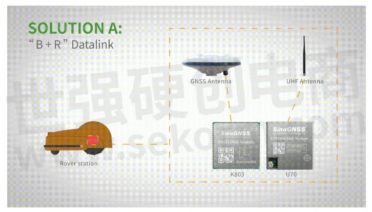
A.“B+R” Datalink
Base station acquires differential data through datalink and provides corrections to rover. The rover station, comprising the parts installed on the lawn mower, including the GNSS antenna, the GNSS high-precision module, datalink, and UHF antenna, enables centimeter-level positioning and navigation.

B. Local CORS Network
Utilizing existed local CORS, rover station obtains differential data from CORS service. In this way, the lawn mower achieves positioning and navigation on a centimeter level.

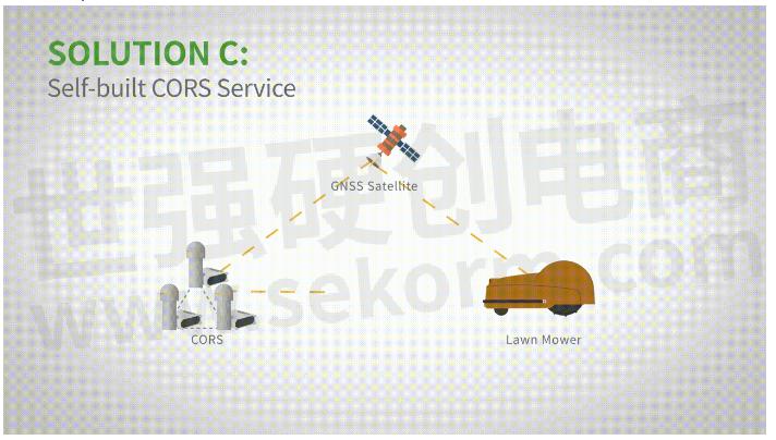
C. Self-built CORS Network
Base stations can be built anywhere based on requirements. It eliminates the worry about prevailing conditions and makes high-precision positioning and navigation of lawn mower possible.

III. Aynalyse of ComNav’s solutions

IV. Features of Product and Technology
Product Features:

Technology Features:
LAI Technology
The Low power anti-interference (LAI) technology is ComNav's patented technology. Its Jamming-to-Signal Ratio is up to 50dB. And power consumption is only 0.1W when turned on.
By fast detecting and eliminating interference with simple settings, LAI technology can reduce failure time and ensure safe operation. Furthermore, the technology can generate a spectrum diagram of interference sources so as to identify the interference types and potential interference sources.
Quantum Algorithm
The Quantum algorithm has sophisticated technology for detecting and repairing cycle slips. Utilizing full-constellation and full-frequency tracking capabilities along with multi-frequency combination, model and parameter estimation, Quantum is able to eliminate the errors caused by ionosphere, troposphere, and multipath in seconds. As a result, the initialization time of RTK is greatly shortened and precision and reliability are improved. Meantime, the extra-long baseline calculation capability expands the operation range.
RTK-KEEP Technology
By estimating model and parameter values, RTK-KEEP Technology can reduce errors caused by the satellite orbit, clock difference, ionosphere, and troposphere when base station's data is lost. Centimeter-level accuracy can be kept for more than ten minutes, greatly improving the availability of RTK.
IIV. Benefits of ComNav’s Solution
1. High Efficiency
ComNav's solution allows the lawn mower to achieve centimeter-level positioning and reduce mowing repetitions.
2. Safety & Reliability
ComNav's solution facilitate the lawnmower to operate safely and reliably in the corners, under trees, or other places where satellite signal is weak or lost.
3. Wide Availability
Having strong anti-interference capabilities, the lawn mower can maintain continuous and effective positioning in complex environments, meeting the needs of a variety of applications.
- |
- +1 赞 0
- 收藏
- 评论 0
本文由深蓝的鱼转载自ComNav technology News,原文标题为:ComNav Technology Launched GNSS High Precision Positioning Solution for Lawn Mower,本站所有转载文章系出于传递更多信息之目的,且明确注明来源,不希望被转载的媒体或个人可与我们联系,我们将立即进行删除处理。
相关推荐
【应用】司南导航高精度GNSS定位模组K803支持GPS和北斗等多模定位系统,助力割草机路径规划应用
割草机在园艺应用大大节省了人工作业成本,传统的割草机仍然需要人工操作,于是一种新型的智能化割草机已被研发出来,能够在规划的区域实现自动割草和充电。本文主要介绍司南导航K803高精度的定位和授时模块,给自动割草机提供时空信息,完成割草路径的精准规划。
应用方案 发布时间 : 2023-07-05
【应用】功耗低至1.6W的定位惯导模组助力手持定位终端设备实现高精度定位,满足小体积需求,支持INS+GNSS导航
本文主要介绍司南导航推出了一款低功耗板载IMU——K823,支持组合导航,功耗低至1.6W的集成惯导和天线的全系统双频点定位定向模组产品,在手持卫星定位终端的应用,以及优势特性。
应用方案 发布时间 : 2023-05-26
【应用】司南导航基于北斗/GNSS高精度定位定向模块K8,提供超强抗干扰的厘米级精准农业解决方案
司南导航基于K8系列北斗/GNSS高精度定位定向模块,利用GNSS卫星的定位定向数据辅助农机设备进行现场作业,在作业过程中实时提供精准的位置、方向信息,厘米级定位辅助导航路径规划,具备高精度、高可用、高覆盖等性能优势。
应用方案 发布时间 : 2022-09-20
司南导航定位模块/转接板选型表
GNSS高精度定位模块是司南导航自主研发的多系统多频点的小尺寸高精度定位模块,支持BDS-3、GPS、BDS-2、GLONASS、Galileo、QZSS 等卫星导航系统的信号跟踪,定位精度高,适用于物联网、智能驾驶、无人机、智能机器人等领域。
|
产品型号
|
品类
|
包装形式
|
尺寸(mm)
|
特点
|
频点
|
BDS(信号跟踪)
|
GPS(信号跟踪)
|
GLO(信号跟踪)
|
GAL(信号跟踪)
|
QZSS(信号跟踪)
|
SPP(定位精度)
|
DGPS(定位精度)
|
RTK(定位精度)
|
伪距精度(cm)
|
载波相位精度(mm)
|
速度精度(m/s)
|
I/O
|
冷启动(S)
|
热启动(S)
|
重捕(S)
|
初始化(S)
|
IO引脚
|
重量(g)
|
输入电压(V)
|
功耗(w)
|
|
K801
|
GNSS高精度定位模块
|
真空密封的铝箔放静电袋
|
12mm×16mm×2.4mm
|
小尺寸定位
|
多频
|
B1I,B2a
|
L1C/A,L5
|
G1
|
E1,E5a
|
L1C/A,L5
|
H:≤1.5m V:≤3.0m
|
H:≤0.3m V:≤0.5m
|
H:≤8+Dx10-6mm V:≤15+Dx10-6mm
|
≤10cm
|
≤1mm
|
≤0.02m/s
|
LVCMOS×2,PPS×1,EVENT×1,SPI×1
|
<24S
|
<1S
|
<1S
|
<5S
|
LGA 24Pin,1.1mm
|
3g
|
+3.3V DC
|
0.1w
|
选型表 - 司南导航 立即选型
司南导航(Comnav Technology)K8系列北斗/GNSS高精度定位模块选型指南
描述- 上海钦天导航技术有限公司是上海司南卫星导航技术股份有限公司全资子公司,成立于2022年,是一家集硏发、生产、销售、服务为一体的高精度北斗/GNSS技术领军企业,拥有一支多年专业从事高精度GNSS核心技术的本土硏发团队,主要技术骨干百余人次获得省部级及以上科学技术奖项,核心团队打破国外多项技术壁垒,突破高精度GNSS核心算法、芯片、板卡、终端、应用及产业化等关键技术瓶颈,经业内专家鉴定钦天高精度GNSS技术已达到世界先进水平,相关产品入选国家卫星导航专顼北斗基础产品推荐名录。
型号- EVK-QD302,CRU,K8-U70,RD02,K803+U70,CDL7,K系列,QD302,K803_EK0405,EVK-K823,U703,EVK-K803,K803_EK0407,K801,K823,W803,GBAS,K802,U70,K827,K803,K823_EK0407,K807,K8系列,K823+U70,K803_EK0610
【IC】司南导航新品单北斗全国产高精度RTK定位模组K803G/23G,低功耗高集成,引领定位技术新进程
随着北斗导航系统的建设完成,“中国芯”的研发实力日益攀升。司南导航立足产品研发,以自主创新突破技术瓶颈,K803G/K823G单北斗RTK高精度定位模组在性能、稳定性、可靠性等多方面均有突破,公司将持续攻坚,严格把好质量关,充分满足各行业高精度位置服务需求,推动北斗规模化应用高质量发展。
产品 发布时间 : 2023-11-15
【经验】北斗三号精密单点定位(PPP-B2b)技术及应用——以司南导航EVK-K8评估套件为例
PPP-B2b是北斗系统首次对外发布的高精度信号,由北斗三颗地球同步轨道(GEO)卫星播发,为用户提供公开、免费的高精度服务。本文将介绍北斗三号精密单点定位(PPP-B2b)技术及应用——以司南导航EVK-K8评估套件为例。
设计经验 发布时间 : 2022-07-13
司南导航(Comnav Technology)GNSS模块选型表
描述- 上海司南卫星导航技术股份有限公司成立于2012年(股票代码:688592),是国内自主掌握高精度北斗/GNSS模块核心技术并成功实现规模化市场应用的高新技术企业,集研发、生产、销售、服务为一体,致力于为全球用户提供全方位、多领域的高精度北斗/GNSS芯片、板卡、终端和系统解决方案。
型号- K827,K823E,K8,K803‐U70,K9,K803_EK0405,K803 LITE‐QD302,EVK‐K823,EVK‐K803,K802S,K823‐U70,K803_EK0407,K11,K10,K801,K823,K802,K803LITE,K803,K825,K823_EK0407,K803S5,K807,K825S,K827S,K803_EK0610,K801S,K823S
电子商城
服务
Ignion可支持多协议、宽频段的物联网天线方案设计,协议:Wi-Fi、Bluetooth、UWB、Lora、Zigbee、2G、3G、4G、5G、CBRS、GNSS、GSM、LTE-M、NB-IoT等,频段范围:400MHz~10600MHz。
最小起订量: 2500 提交需求>


登录 | 立即注册
提交评论