How Does GNSS Technology Contribute to Autonomous Driving?


GNSS (Global Navigation Satellites System) is a world-level fusion project, to offer high-precision solutions worldwide. By capturing satellites from different constellations such as GPS (from USA), GLONASS (from Russia), Beidou (from China), GALILEO (from Europe), QZSS (from Japan), NavIC (from India) and other SBAS, L-band, etc services, nowadays GNSS can deliver a highly accurate and stable positioning everywhere.

Our daily needs, ranging from smartphone positioning, vehicle navigation, and smartwatches to emerging drone mapping and drone solution seeding, etc, are exemplary manifestations of accurate positioning. GNSS technology has brought a lot of convenience to our lives, for example, autonomous driving development and CORS covering every country, and this positive impact will be reflected in more aspects.
Taking the current autonomous driving system as an example, equipped with ComNav’s K803 GNSS Module (GNSS+INS supported), it enables to the provision of higher reliability and higher integrity positioning information. The positioning data can output under most of the challenging conditions in rainy, snowy, or foggy environments, to reach lane-level navigation. Thanks to the higher accuracy positioning, map matching can be performed in a smaller range meanwhile the required computing power is reduced. Working with other sensors, GNSS technology provides a strong backup for the safety of autonomous driving. The other significant result is map cost is slowed down to a large extent.

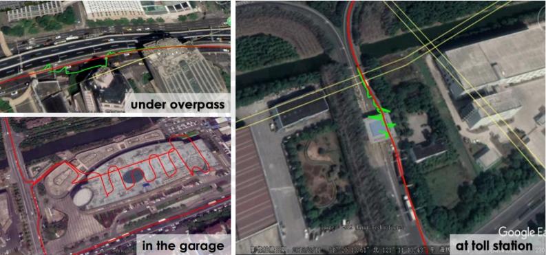
GNSS+INS navigation GNSS navigation only
Compared with the GNSS-only positioning system, the GNSS+INS system can significantly enhance navigation performance, wherever in the urban canyon, near buildings, under heavy tree cover, or even in a tunnel.
GNSS technology ensures accurate, stable, and reliable positioning navigation results, to help vehicles get their real location. With its fusion with other sensors like LiDAR, bomb-wave radar, cameras, etc, vehicles get more accurate positioning and heading and an overall and accurate understanding of the current environment to facilitate the vehicle making the next decision.
Ushering in the area of a connected future, GNSS and high-precision positioning services will definitely play a key role and be the cornerstone to building up the future world. It is clear to see that more and more functions of the vehicles depend on high-accuracy location. GNSS, initially, helped us find the fastest route to a destination. Finally, we do believe it will help us drive autonomously.
- |
- +1 赞 0
- 收藏
- 评论 0
本文由翊翊所思转载自ComNav Technology News,原文标题为:How does GNSS technology contribute to autonomous driving?,本站所有转载文章系出于传递更多信息之目的,且明确注明来源,不希望被转载的媒体或个人可与我们联系,我们将立即进行删除处理。
相关推荐
Recommend Commands for System Integration
As more and more of users integrate ComNav high precision GNSS modules into various applications, such as Robotics, UAV, Surveying and Mapping, Precision Agriculture, Automatic Driving, to improve the system‘s debuggability, it is advisable to reserve a port for communication with the internal module in ComNav‘s high precision GNSS modules. This allows users to easily view module information at a later time and access the data for analysis when needed.
The Magic Behind RTK: Delivering Unparalleled Positioning Precision
In today‘s advanced technological era, accurate positioning has become a cornerstone for numerous applications, ranging from agriculture to construction and beyond. But what exactly is RTK, and how does it stand out in the vast landscape of satellite navigation systems?
How does GNSS module affect RTK performance in the field?
A GNSS receiver’s accuracy, stability and anti-interference mainly determined by a GNSS module’s various attributes such as supported signal types and quantities, speed and stability of satellite tracking, quality of original observations, positioning accuracy, etc.
司南导航定位模块/转接板选型表
GNSS高精度定位模块是司南导航自主研发的多系统多频点的小尺寸高精度定位模块,支持BDS-3、GPS、BDS-2、GLONASS、Galileo、QZSS 等卫星导航系统的信号跟踪,定位精度高,适用于物联网、智能驾驶、无人机、智能机器人等领域。
|
产品型号
|
品类
|
包装形式
|
尺寸(mm)
|
特点
|
频点
|
BDS(信号跟踪)
|
GPS(信号跟踪)
|
GLO(信号跟踪)
|
GAL(信号跟踪)
|
QZSS(信号跟踪)
|
SPP(定位精度)
|
DGPS(定位精度)
|
RTK(定位精度)
|
伪距精度(cm)
|
载波相位精度(mm)
|
速度精度(m/s)
|
I/O
|
冷启动(S)
|
热启动(S)
|
重捕(S)
|
初始化(S)
|
IO引脚
|
重量(g)
|
输入电压(V)
|
功耗(w)
|
|
K801
|
GNSS高精度定位模块
|
真空密封的铝箔放静电袋
|
12mm×16mm×2.4mm
|
小尺寸定位
|
多频
|
B1I,B2a
|
L1C/A,L5
|
G1
|
E1,E5a
|
L1C/A,L5
|
H:≤1.5m V:≤3.0m
|
H:≤0.3m V:≤0.5m
|
H:≤8+Dx10-6mm V:≤15+Dx10-6mm
|
≤10cm
|
≤1mm
|
≤0.02m/s
|
LVCMOS×2,PPS×1,EVENT×1,SPI×1
|
<24S
|
<1S
|
<1S
|
<5S
|
LGA 24Pin,1.1mm
|
3g
|
+3.3V DC
|
0.1w
|
选型表 - 司南导航 立即选型
司南导航(Comnav Technology)K8系列北斗/GNSS高精度定位模块选型指南
目录- 公司介绍 核心技术 K系列模块对比表 高精度模块 数传模块 北斗RDSS短报文通信模块 行业应用 服务与支持 生产与管理
型号- EVK-QD302,CRU,K8-U70,RD02,K803+U70,CDL7,K系列,QD302,K803_EK0405,EVK-K823,U703,EVK-K803,K803_EK0407,K801,K823,W803,GBAS,K802,U70,K827,K803,K823_EK0407,K807,K8系列,K823+U70,K803_EK0610
【应用】司南导航高精度GNSS定位模组K803支持GPS和北斗等多模定位系统,助力割草机路径规划应用
割草机在园艺应用大大节省了人工作业成本,传统的割草机仍然需要人工操作,于是一种新型的智能化割草机已被研发出来,能够在规划的区域实现自动割草和充电。本文主要介绍司南导航K803高精度的定位和授时模块,给自动割草机提供时空信息,完成割草路径的精准规划。
【IC】司南导航新品单北斗全国产高精度RTK定位模组K803G/23G,低功耗高集成,引领定位技术新进程
随着北斗导航系统的建设完成,“中国芯”的研发实力日益攀升。司南导航立足产品研发,以自主创新突破技术瓶颈,K803G/K823G单北斗RTK高精度定位模组在性能、稳定性、可靠性等多方面均有突破,公司将持续攻坚,严格把好质量关,充分满足各行业高精度位置服务需求,推动北斗规模化应用高质量发展。
K系列OEM板用户指南
描述- 本指南为ComNav Technology K系列OEM板提供了安装、配置和操作说明。指南涵盖了OEM板的概述、评估套件、相关文档、安装指南、CRU软件配置、工作模式配置、常用命令和固件更新等内容。指南详细介绍了如何使用CRU软件进行OEM板的配置,包括状态检查、命令接口、NTRIP配置、数据记录配置和数据管理。此外,还介绍了不同工作模式的配置,如平滑模式、SBAS模式、RTK模式、RTD模式和移动基线模式。最后,指南还提供了常用命令的说明。
型号- K728,K706,K726,K803,K705,K708,K-SERIES,K823,K700,K8-SERIES
【经验】北斗三号精密单点定位(PPP-B2b)技术及应用——以司南导航EVK-K8评估套件为例
PPP-B2b是北斗系统首次对外发布的高精度信号,由北斗三颗地球同步轨道(GEO)卫星播发,为用户提供公开、免费的高精度服务。本文将介绍北斗三号精密单点定位(PPP-B2b)技术及应用——以司南导航EVK-K8评估套件为例。
K802 GNSS模块
描述- K802是一款尺寸为22mm×17mm×2.8mm的GNSS模块,具备多系统支持、高精度定位和低功耗等特点。该模块采用ComNav的QUANTUMⅢSoC芯片,适用于专业级应用,支持GNSS+INS导航,并具备RTK定位功能。
型号- K SERIES,K802
Neoway Technology Launches a Diverse GNSS Module Portfolio: Enhancing Positioning Services with Greater Accuracy and Speed
This year, Neoway Technology launched a diverse GNSS module portfolio. These modules are designed for diverse sectors such as electric power, logistics tracking, vehicular navigation, vehicle monitoring, robotics, geospatial monitoring, and unmanned aerial vehicles (UAVs). Offering high fix rates, precision, and reliability, these modules are tailored to meet the requirements of different regions and scenarios.
司南导航(Comnav Technology)GNSS模块选型表
目录- GNSS模块
型号- K827,K823E,K8,K803‐U70,K9,K803_EK0405,K803 LITE‐QD302,EVK‐K823,EVK‐K803,K802S,K823‐U70,K803_EK0407,K11,K10,K801,K823,K802,K803LITE,K803,K823_EK0407,K825,K803S5,K807,K825S,K827S,K803_EK0610,K801S,K823S
电子商城
服务
Ignion可支持多协议、宽频段的物联网天线方案设计,协议:Wi-Fi、Bluetooth、UWB、Lora、Zigbee、2G、3G、4G、5G、CBRS、GNSS、GSM、LTE-M、NB-IoT等,频段范围:400MHz~10600MHz。
最小起订量: 2500 提交需求>


登录 | 立即注册
提交评论