How to Enable GNSS+INS System on ComNav K8 Series GNSS Modules


GNSS (Global Navigation Satellite System) is a satellite-based positioning system that provides location and time information anywhere on or near the Earth's surface. Examples of GNSS include GPS, GLONASS, Galileo, and BeiDou.
INS (Inertial Navigation System), on the other hand, is a self-contained navigation system that uses accelerometers and gyroscopes to track the movement of an object. By measuring changes in velocity and direction, INS can calculate an object's current position and trajectory. INS is particularly useful in areas where GNSS signals are weak or unavailable, such as underground or underwater.
In many cases, GNSS and INS are used together to provide a more accurate and reliable navigation solution. This is known as integrated navigation or GNSS/INS integration. ComNav K8-series GNSS modules combine the strengths of both systems, integrated navigation can be robust in challenging environments and provides continuous positioning even during short GNSS outages, here are some examples of K8 GNSS+INS performance in different environments.
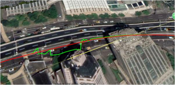
Under overpass
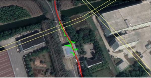
Through subway station
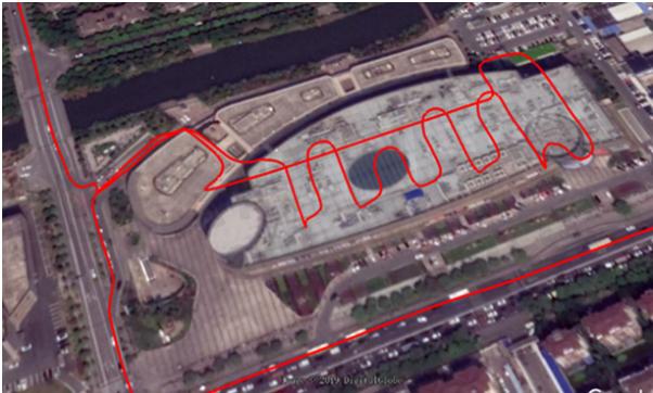
In the Garage
Installation and setup
1) Installation
Install the board on the vehicle as rigidly as possible to ensure that the board and the vehicle will not move relative to each other during driving. The device also needs to be installed in a location that minimizes the impact of vibration and electromagnetic interference.
2) Setup INS mode
After installation, you can activate the INS option as a command

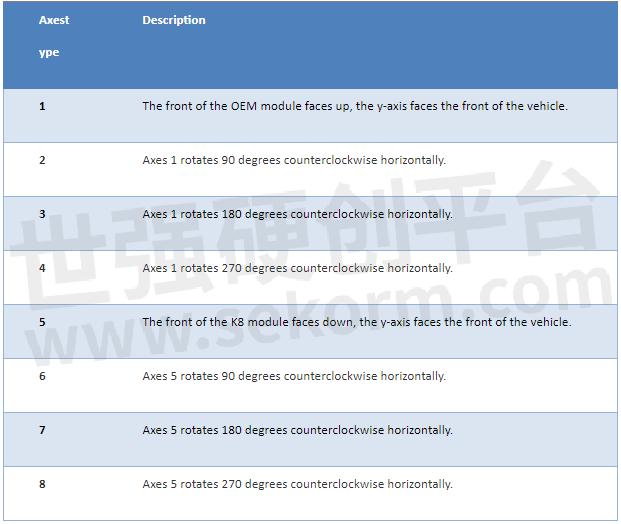
It is recommended that the Y-axis marked on the module be kept on the same straight line as the direction of the carrier body, that is, Y-axis points to the forward direction of the vehicle. For the different directions of installation, you can refer to the below chart to set up the imuaxestype with the command below.
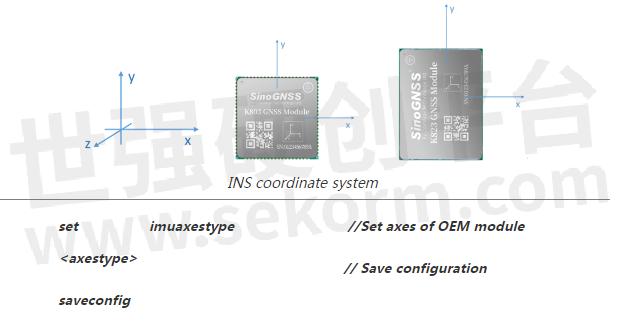
3) Setup Drleverarm value
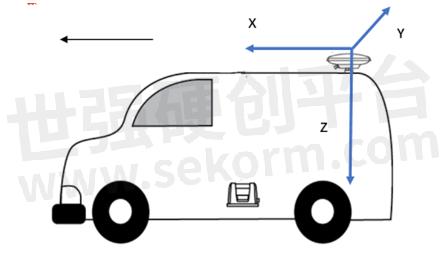
Drleverarm value: the three-axis vector from the antenna phase center to the INS phase center.

Note: The XYZ is not related to the axis of INS. X points to the front of the vehicle, Y points to the right of the vehicle, and Z points downward.
4) Save INS configuration
Once change the above INS configuration, it will need “reset” to the board to save the INS configuration.
INS Initialization
The inertial navigation system (INS) calculates the navigation result by integrating the measurement value of the inertial sensor, that is, each iteration of the navigation equation needs to use the previous navigation parameters such as position, velocity, and attitude as its initial value. Therefore, before using INS to provide navigation results, it must be initialized.
Method: After enabling INS, there will need first to get correction input to get RTK fixed solution, and then drive the vehicle to an open environment, make sure the speed reaches the initialization threshold, and drive about 10m to complete the initialization.
INS Calibration
In order to ensure the performance of INS, it needs to be calibrated after the initialization is completed to eliminate the placement error of the INS equipment.
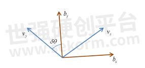
Method: Keep a speed of 5m/s in an open environment and drive in a straight line for at least 200m, turning 90° for left and right twice for each (with a good road environment, you can turn around in Figure 8).
The status of calibration can be checked by the message “sysrts”. After calibrated, the status of INS will be “3”.

Here is a sample output of the SYSRTS message:
$SYSRTS,466724.10,093826.10,48,5,,AT,41,78,1,1,49,,,,,,,,,M,AIR,0,,42.5,3,9,2200,0,0*3A
There are totally 4 different types of status for INS, as the below table lists:

Positioning and heading message
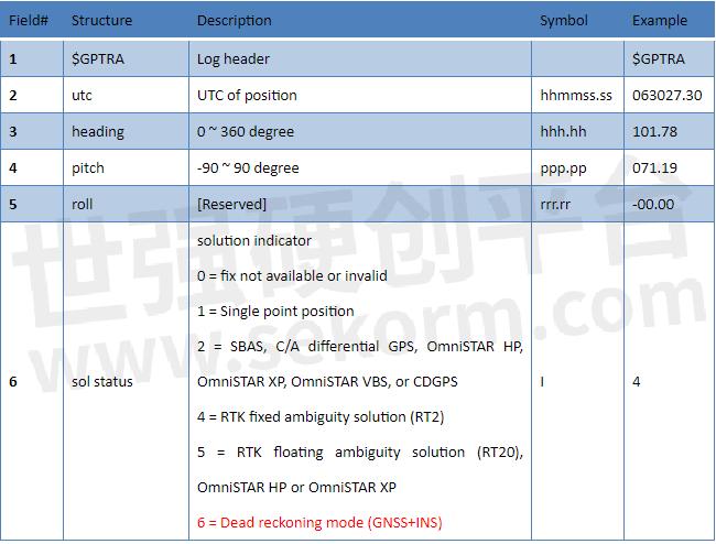
Request positioning and heading message with GPGGA message and GPTRA message.

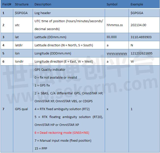
In the GPGGA message, the solution status for GNSS+INS is “6”; In the GPTRA message, the solution status for GNSS+INS is “6”.
Example of GPGGA message
$GPGGA,024941.00,3110.4693903,N,12123.2621695,E,6,16,0.6,57.0924,M,0.000,M,99,AAAA*55
Example of GPTRA message
$GPTRA,063027.30,101.78,071.19,-00.00,6,10,0.00,0004*51
About ComNav Technology
ComNav Technology is the major provider of GNSS OEM boards, receivers, and high-precision positioning solutions, encompassing product development, and marketing. Its technology and products have already been applied in a wide range of fields such as surveying, construction, machine control, agriculture, intelligent transportation, precise timing, deformation monitoring, and unmanned system. With its experienced team and innovational spirit, ComNav Technology is always trying its best to provide reliable and competitive products to global customers. In 2015, ComNav Technology was listed on the China National Equities Exchange and Quotations (NEEQ), Securities: ComNav Technology (Compass Navigation).
About SinoGNSS®
SinoGNSS® is the official trademark of ComNav Technology Ltd., registered in the People’s Republic of China, EU, USA, and Canada. All other trademarks are the property of their respective owners.
- |
- +1 赞 0
- 收藏
- 评论 0
本文由翊翊所思转载自ComNav Technology News,原文标题为:How to Enable GNSS+INS system on K8 series modules,本站所有转载文章系出于传递更多信息之目的,且明确注明来源,不希望被转载的媒体或个人可与我们联系,我们将立即进行删除处理。
相关推荐
【经验】深度解析GNSS模块的冷/热启动是什么?
GNSS的基本定位原理是卫星不间断地发送自身的星历参数和时间信息,用户在接收到这些信息后,经过计算得出模块的三维位置、三维方向以及运动速度和时间信息。信号强度、芯片运算能力存在差异,将模块定位时长按快慢进行排序:热启动>温启动>冷启动。
GNSS Spectrum Function and Low-power Anti-interference Technology for ComNav Technology K8-series GNSS Module
Low-power Anti-interference (LAI) technology is ComNav patented advanced anti-narrowband and anti-continuous-wave interference technology. The SNR can reach 60dB and the power consumption is only 0.1W when enabled.
How to Active the Event Option for Your GNSS Module K8 series from ComNav Technology
Event technology refers to enhancing the acquisition and utilization of location information by capturing and processing specific events related to location.The technology records the precise moment and precise coordinate information of an event. When the module receives the EVENT triggers pulse signal, it locks the data at the corresponding time in time for processing, and outputs the original observation, time, position and other information.
司南导航(Comnav Technology)K8系列北斗/GNSS高精度定位模块选型指南
目录- 公司介绍 核心技术 K系列模块对比表 高精度模块 数传模块 北斗RDSS短报文通信模块 行业应用 服务与支持 生产与管理
型号- EVK-QD302,CRU,K8-U70,RD02,K803+U70,CDL7,K系列,QD302,K803_EK0405,EVK-K823,U703,EVK-K803,K803_EK0407,K801,K823,W803,GBAS,K802,U70,K827,K803,K823_EK0407,K807,K8系列,K823+U70,K803_EK0610
【技术】GNSS模块/板卡数据质量快速评估方法详解:零基线法和原始数据质量分析法
随着北斗三号的全球组网以及LBS、物联网和智能驾驶的发展,GNSS模块开始向小型化、集成化方向发展,GNSS应用也从专业应用走向大众应用。对用户而言,GNSS仍具有较强的专业性,在使用中难免会遇到各类问题。本文介绍GNSS模块的快速评估方法供大家参考。
K系列OEM板用户指南
描述- 本指南为ComNav Technology K系列OEM板提供了安装、配置和操作说明。指南涵盖了OEM板的概述、评估套件、相关文档、安装指南、CRU软件配置、工作模式配置、常用命令和固件更新等内容。指南详细介绍了如何使用CRU软件进行OEM板的配置,包括状态检查、命令接口、NTRIP配置、数据记录配置和数据管理。此外,还介绍了不同工作模式的配置,如平滑模式、SBAS模式、RTK模式、RTD模式和移动基线模式。最后,指南还提供了常用命令的说明。
型号- K728,K706,K726,K803,K705,K708,K-SERIES,K823,K700,K8-SERIES
实现毫米级实时定位,司南导航提供车规级高精度GNSS定位模块
2022年5月1日,司南导航(股票代码:833972)与世强达成合作,授权世强代理旗下全线产品,为用户提供全方位、多领域的高精度北斗芯片和高精度GNSS芯片、板卡、终端和系统解决方案。司南导航产品已全线上线平台,搜索“司南导航”即可获取更多产品资讯。
司南导航:深耕高精度北斗技术,助推行业创新发展
企业如何加快培育新质生产力?荣获上海专精特新“小巨人”企业市场竞争力指数百强企业前十的上海司南卫星导航技术股份有限公司,以“北斗高精度+”为布局,瞄准北斗创新应用和技术前沿,厚植新质生产力,正积极塑造未来发展新动能和新优势。
司南导航(Comnav Technology)GNSS模块选型表
目录- GNSS模块
型号- K827,K823E,K8,K803‐U70,K9,K803_EK0405,K803 LITE‐QD302,EVK‐K823,EVK‐K803,K802S,K823‐U70,K803_EK0407,K11,K10,K801,K823,K802,K803LITE,K803,K823_EK0407,K825,K803S5,K807,K825S,K827S,K803_EK0610,K801S,K823S
【应用】司南导航AG360北斗农机自动驾驶系统助力农机导航,定位误差不超过±2.5厘米且支持AB线共享作业
司南导航的农机导航产品,不仅操作简单、信号稳定、适配广泛,而且还提供24小时售后服务。让农业生产更加高效、节省成本,同时保证农业生产的质量和产量,为农业生产带来更多的福音。
司南导航携最新科技成果及行业应用解决方案亮相首届河北省测绘地理信息大会
3月6日-8日,以“科技引领·创新驱动·跨界融合·产业强省”为主题的第一届河北地理信息大会在石家庄国源朗怡酒店盛大召开。司南导航携最新科技成果及行业应用解决方案亮相T022展位,与参会专家和企事业代表交流最新地理信息技术成果,共谋测绘地理信息赋能高质量发展新图景。
【应用】司南导航北斗/GNSS农机自动导航驾驶系统用于水田喷药机,具有快准省稳、上坡下地零压力等优势
由于喷药设备重心较高,北斗自动导航驾驶设备安装过程较为繁琐,同时,为保证用户的使用安全,需要在自动驾驶控制方面增加特殊保护机制,这项技术在国内较为罕见。司南导航此项技术的成功运用,填补了北斗自动导航驾驶系统在水田喷药机应用上的一项空白。
司南导航以北斗/GNSS芯片、板卡/模块为支撑,加速推进“北斗+”应用
在向“新”而生、提质升级浪潮的推动下,司南导航以北斗/GNSS芯片、板卡/模块为支撑,探索“北斗+”创新沃土,牢牢把握高质量发展的首要任务,因地制宜发展新质生产力,加速融入测量测绘、精准农业、形变监测、智能驾驶、数字施工、人员定位等行业的基础设施建设,为北斗高精度定位服务的安全、稳定、可靠提供有力保障。
【应用】司南导航基于北斗/GNSS高精度定位定向模块K8,提供超强抗干扰的厘米级精准农业解决方案
司南导航基于K8系列北斗/GNSS高精度定位定向模块,利用GNSS卫星的定位定向数据辅助农机设备进行现场作业,在作业过程中实时提供精准的位置、方向信息,厘米级定位辅助导航路径规划,具备高精度、高可用、高覆盖等性能优势。
致礼北斗科研 | EVK-北斗开发套件免费体验活动启动!
EVK-北斗开发套件免费体验活动启动!K8系列评估板(以下简称EVK-K8)是一款具备高精度定位和定向功能的套件,提供多种电气接口,实时交互式显示,易于使用,可扩展性强。适用于K系列RTK模组功能、性能的测试评估。
电子商城
品牌:SILICON LABS
品类:high-performance low-current receiver
价格:¥15.9807
现货: 490
品牌:SILICON LABS
品类:HIGH-PERFORMANCE LOW-CURRENT RECEIVER
价格:¥25.9222
现货: 470
品牌:SILICON LABS
品类:HIGH-PERFORMANCE LOW-CURRENT RECEIVER
价格:¥25.9222
现货: 0
现货市场
服务
拥有中等规模的SMT、DIP以及成品组装产线;支持PCBA及成品OEM/ODM代工组装制造;在嵌入式系统、物联网系统等具备专业性量产制造的项目组织和服务能力。
提交需求>
Ignion可支持多协议、宽频段的物联网天线方案设计,协议:Wi-Fi、Bluetooth、UWB、Lora、Zigbee、2G、3G、4G、5G、CBRS、GNSS、GSM、LTE-M、NB-IoT等,频段范围:400MHz~10600MHz。
最小起订量: 2500 提交需求>


登录 | 立即注册
提交评论